


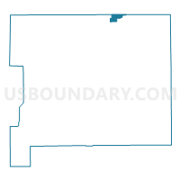
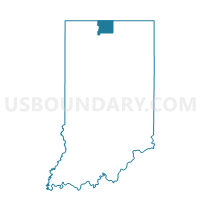
CLAY TWP 11, St. Joseph County, Indiana
About
Outline

Summary
| Unique Area Identifier | 580534 |
| Name | CLAY TWP 11 |
| County | St. Joseph County |
| State | Indiana |
| Area (square miles) | 1.34 |
| Land Area (square miles) | 1.34 |
| Water Area (square miles) | 0.00 |
| % of Land Area | 100.00 |
| % of Water Area | 0.00 |
| Latitude of the Internal Point | 41.75395720 |
| Longtitude of the Internal Point | -86.22001690 |
Maps

Graphs
Select a template below for downloading or customizing gragh for CLAY TWP 11, St. Joseph County, Indiana


Neighbors
Neighoring Voting District (by Name) Neighboring Voting District on the Map
- Voting District 0215778000004, Berrien County, MI
- Voting District 0275446000001, Cass County, MI
- CLAY TWP 08, St. Joseph County, IN
- CLAY TWP 09, St. Joseph County, IN
- CLAY TWP 13, St. Joseph County, IN
- CLAY TWP 20, St. Joseph County, IN
- CLAY TWP 21, St. Joseph County, IN
Top 10 Neighboring County Subdivision (by Population) Neighboring County Subdivision on the Map
- Clay township, St. Joseph County, IN (32,550)
- Niles township, Berrien County, MI (14,164)
- Milton township, Cass County, MI (3,878)
Top 10 Neighboring Place (by Population) Neighboring Place on the Map
Top 10 Neighboring Unified School District (by Population) Neighboring Unified School District on the Map
Top 10 Neighboring State Legislative District Lower Chamber (by Population) Neighboring State Legislative District Lower Chamber on the Map
- State House District 59, MI (95,808)
- State House District 78, MI (86,900)
- State House District 8, IN (59,962)
Top 10 Neighboring State Legislative District Upper Chamber (by Population) Neighboring State Legislative District Upper Chamber on the Map
Top 10 Neighboring 111th Congressional District (by Population) Neighboring 111th Congressional District on the Map
Top 10 Neighboring Census Tract (by Population) Neighboring Census Tract on the Map
- Census Tract 18, Cass County, MI (8,165)
- Census Tract 113.02, St. Joseph County, IN (6,522)
- Census Tract 113.05, St. Joseph County, IN (4,389)
- Census Tract 113.04, St. Joseph County, IN (2,427)
- Census Tract 212, Berrien County, MI (1,615)